The challenge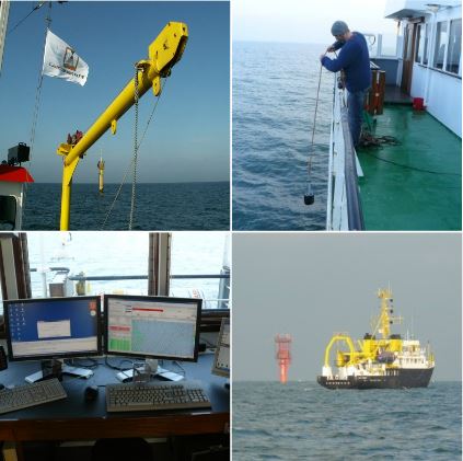 With this project the Department of Mobility and Public Works aims to guarantee a more efficient and cost effective service in a sector of importance for Flanders.
Hydrographic surveys are three-dimensional surveys allowing the topography of the ocean floor and river beds to be mapped. The Flemish government annually spends several million euros on hydrographic surveying of the Belgian part of the North Sea and the Scheldt estuary.
Executing these hydrographic surveys faces some important limitations:
- Survey areas are limited by what is feasible within a single survey day. Consequently, large areas need multiple survey days (up to weeks) with eventually multiple survey vessels and certain areas have a low revisit frequency (up to multiple years). It is clear that data acquisition and processing are costly and labour intensive.
- Even more efforts are needed to adequately cover the intertidal part of coastal areas. Bathymetric surveys need to be scheduled at high water, resulting in slower acquisition rates. Laser scanning surveys need optimal weather conditions and need to be scheduled at low water. Combining both survey results into a single map covering the area of interest is complex and adds to the costs of data acquisition.
To deal with challenges the Department of Mobility and Public Works – in cooperation with PIP ( the Programme for Innovation Procurement) seeks an innovative solution to survey the depth of coastal areas:
- Over a large spatial extent (f.i. the whole Western Scheldt)
- Instantaneous, meaning within the same survey effort (f.i. on 1 day)
- Both in shallow turbid water and on adjacent intertidal and supratidaal areas
- with a similar spatial resolution of actual hydrographic and topographic survey methods
With this project the Department of Mobility and Public Works aims to guarantee a more efficient and cost effective service in a sector of importance for Flanders.
Open market consultation
A written open market consultation is held to validate the ‘state of the art’ on hydrographic surveys or digital elevation models (DEMs). All operators, knowledge institutions and enterprises are invited to participated in this survey.
The survey is available at https://ec.europa.eu/eusurvey/runner/PCPHydrography until 25 September 2017. The survey is conducted in English. A prior information notice about this open market consultation is published on 21 August 2017.
Market consultation reference documents
In 2013 the challenges for hydrographic surveys were elaborated and a ‘state of the art’ was established during an open workshop with knowledge institutions and enterprises.
The results of the market consultation carried on in 2013 are summarised in:
![]() Innovation memorandum: hydrographic surveying
Innovation memorandum: hydrographic surveying
A more extensive explanation about the market consultation is provided in:
Contact
ir. Frederik RooseProjectcoördinator Onderzoek en Monitoring T +32 3 222 08 18 M +32 473 92 78 07 |